North-South Segment 2 Tier 2 Environmental Impact Statement and Design Concept Report Arizona Farms Road to Interstate 10 (SR 505)
Welcome
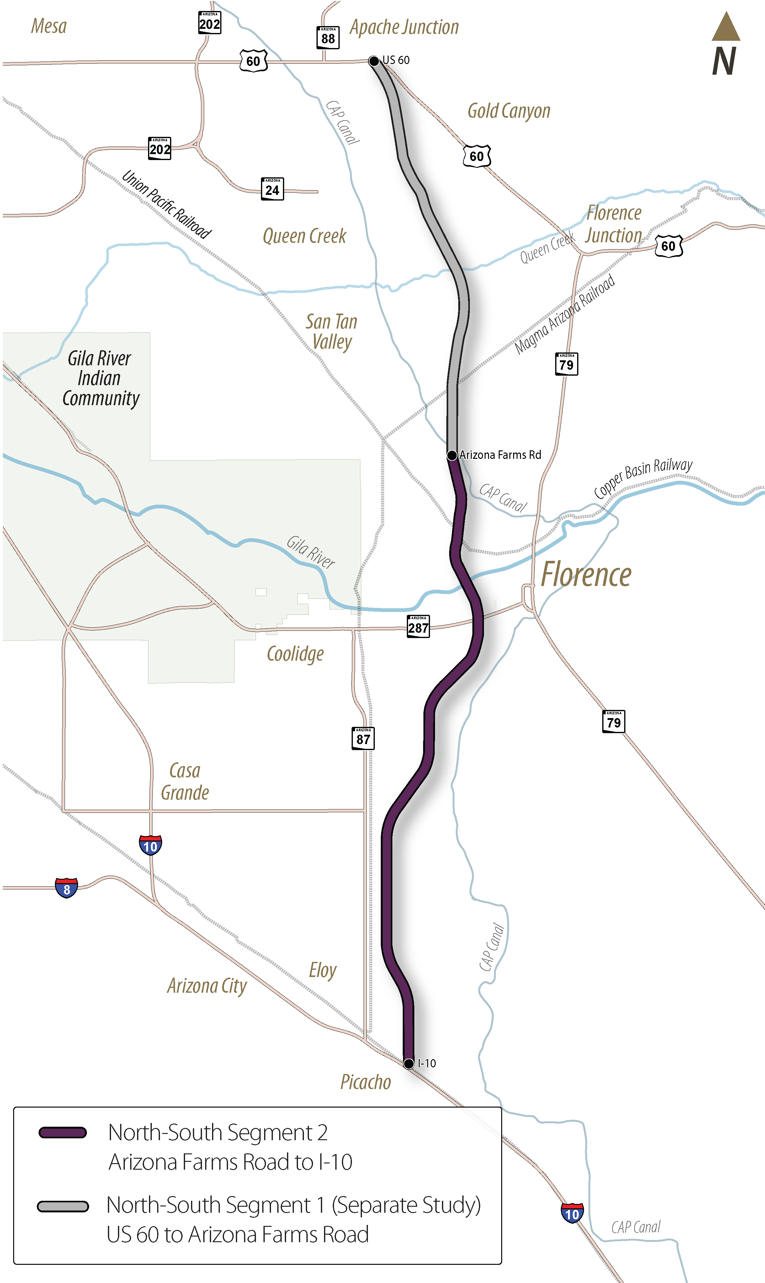
The Arizona Department of Transportation (ADOT) will be conducting a Tier 2 Environmental Impact Statement (EIS) and Design Concept Report (DCR) for North-South Segment 2 from Arizona Farms Road to Interstate 10 (SR 505). Segment 1 of the North-South corridor between US 60 and Arizona Farms Road is a separate but related effort that is also underway.
In 2021, ADOT selected a 1,500-foot North-South Corridor route as part of the previous Tier 1 Environmental Impact Statement (EIS) study. ADOT will now be conducting a Tier 2 EIS study, which will refine the corridor to a preferred 400-foot SR 505 highway alignment and identify the location of interchanges and other features.
The environmental review, consultation and other actions required by applicable Federal environmental laws for this project are being or have been carried out by ADOT pursuant to 23 USC 327 and a Memorandum of Understanding dated 06/25/24 and executed by FHWA and ADOT.
Study Overview
Study Area
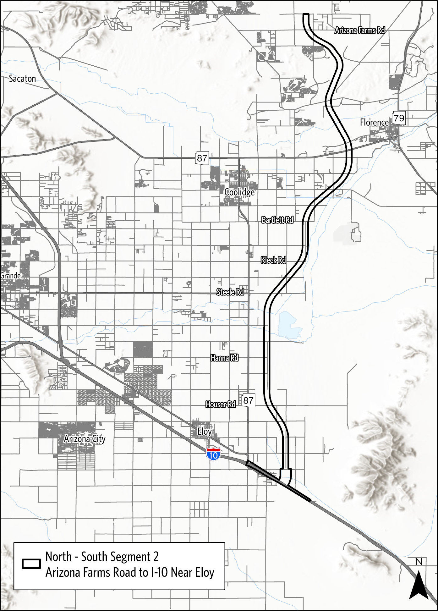
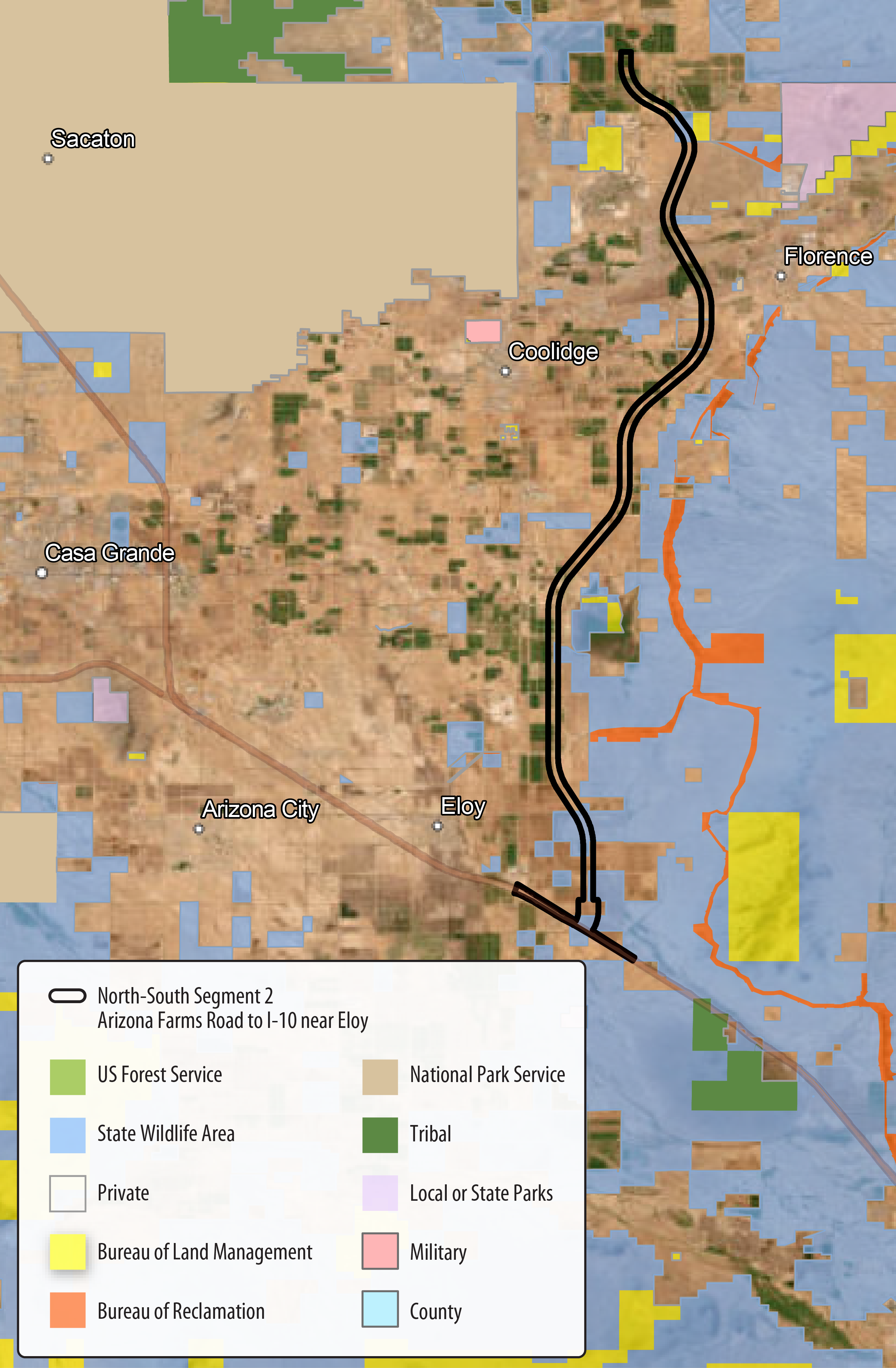
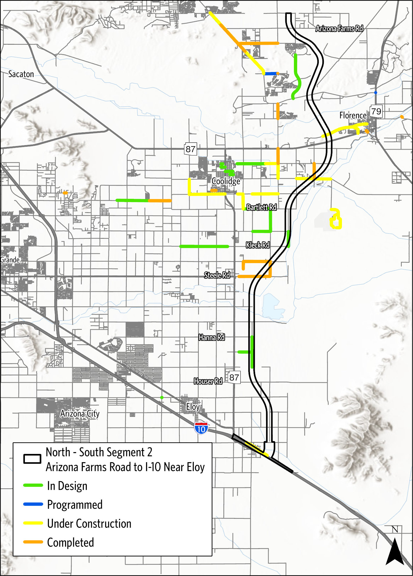
The Segment 2 study corridor spans approximately 31 miles from Florence to Eloy.
Study Goals
The goals of this study are to:
- Identify and evaluate alternatives for a proposed 400-foot freeway alignment within the 1,500-foot Tier 1 corridor that was selected in 2021
- Identify proposed interchange locations and develop interchange design concepts
- Develop and circulate for public review and comment a draft Tier 2 EIS and DCR that identifies the Preferred Build Alternative, which will be compared against the No Build or do nothing alternative
- Prepare a final EIS and DCR document and issue a Record of Decision identifying the Selected Alternative
Study Purpose and Need
The North-South Corridor Study — Tier 1 Environmental Impact Statement/Design Concept Report identified the following purpose and need for the North-South corridor.
A continuous, access-controlled north-to-south transportation corridor would:
- Improve access to future activity centers
- Improve regional mobility
- Improve north-to-south connectivity
- Integrate the region's transportation network
- Address existing and future population and employment growth
- Provide an alternative to avoid congestion on I-10
The Tier 2 study will further refine this purpose and need.
Corridor Features
Existing Features Along Segment 2
- Railroads
- Canals
- Gila River
- Numerous communities
- Picacho Reservoir
- Highways including:
- I-10
- SR 87
- SR 287
- SR 79
- Local roadways including:
- Arizona Farms Road
- Hunt Highway
- Attaway Road
Land Ownership Along Segment 2
- Primarily privately owned and State Trust land
- Includes scattered residences and master-planned communities
- Solar energy facilities
- Utility corridors
- Agricultural lands
- Commercial and manufacturing sites
- Mining
Roadway Planning Efforts
- Future Pinal County arterial street network
Study Timeline and Process
ADOT is currently conducting early public and agency scoping for this study to gather input on what should be considered in refining the purpose and need and preliminary range of alternatives for the North-South Segment 2 alignment, interchange locations and other features. As the study progresses, ADOT will be seeking public, agency and tribal government input on the preliminary range of alternatives for the highway alignment, the study purpose and need or other relevant information for consideration in developing the Tier 2 Draft EIS.
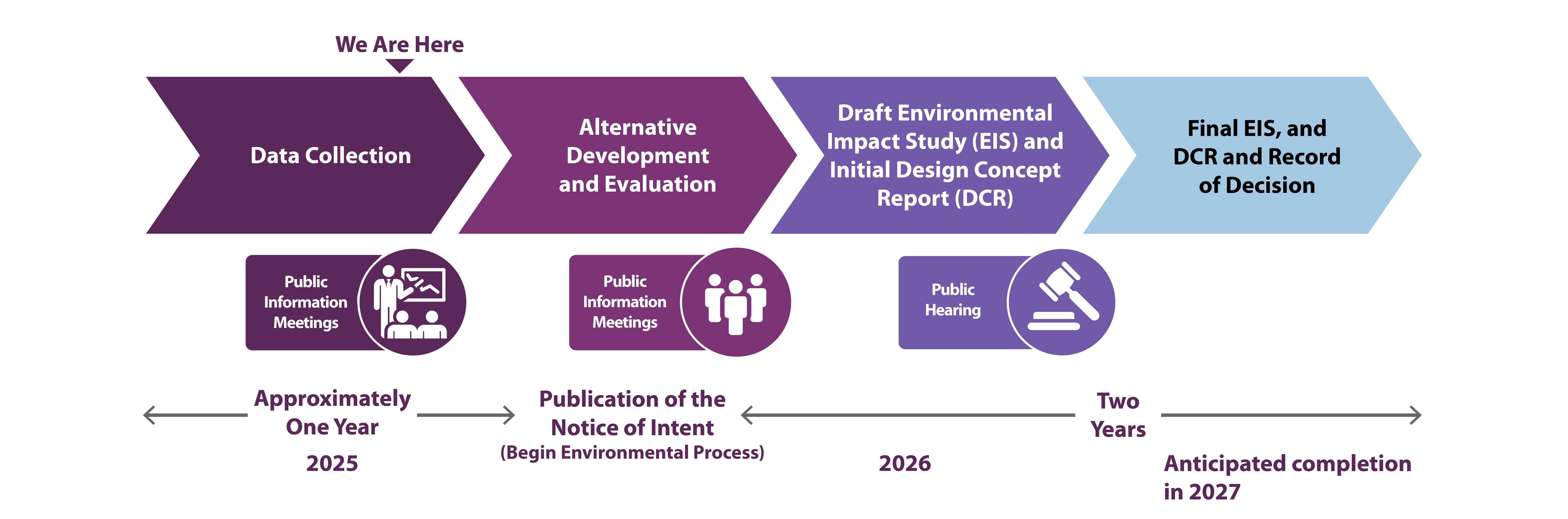
- Early 2025: Data Collection & Public Information Meetings (We are here)
- Late 2025: Alternative Development and Evaluation, Public Information Meetings and Publication of the Notice of Intent
- Early 2026: Draft Environmental Impact Study (EIS) and Initial Design Concept Report (DCR) & Public Hearing
- Late 2026 and 2027: Final EIS, DCR and Record of Decision
- Anticipated completion in 2027
- Temprano 2025: Recolección de Datos (We are here)
- Tarde 2025: Desarrollo y Evalución Alternativos, Reuniones Publicas de Información y Públicación del Aviso de Intención (Comienza el proceso ambiental)
- Temprano 2026: Proyecto de Estudio de Impacto Ambiental (EIS), Informe Conceptual de Diseño Inicial (DCR) y Audiencia Pública
- Tarde 2026 y 2027: EIS Final y DCR y Registro de Decisión
- Finalización prevista para el 2027
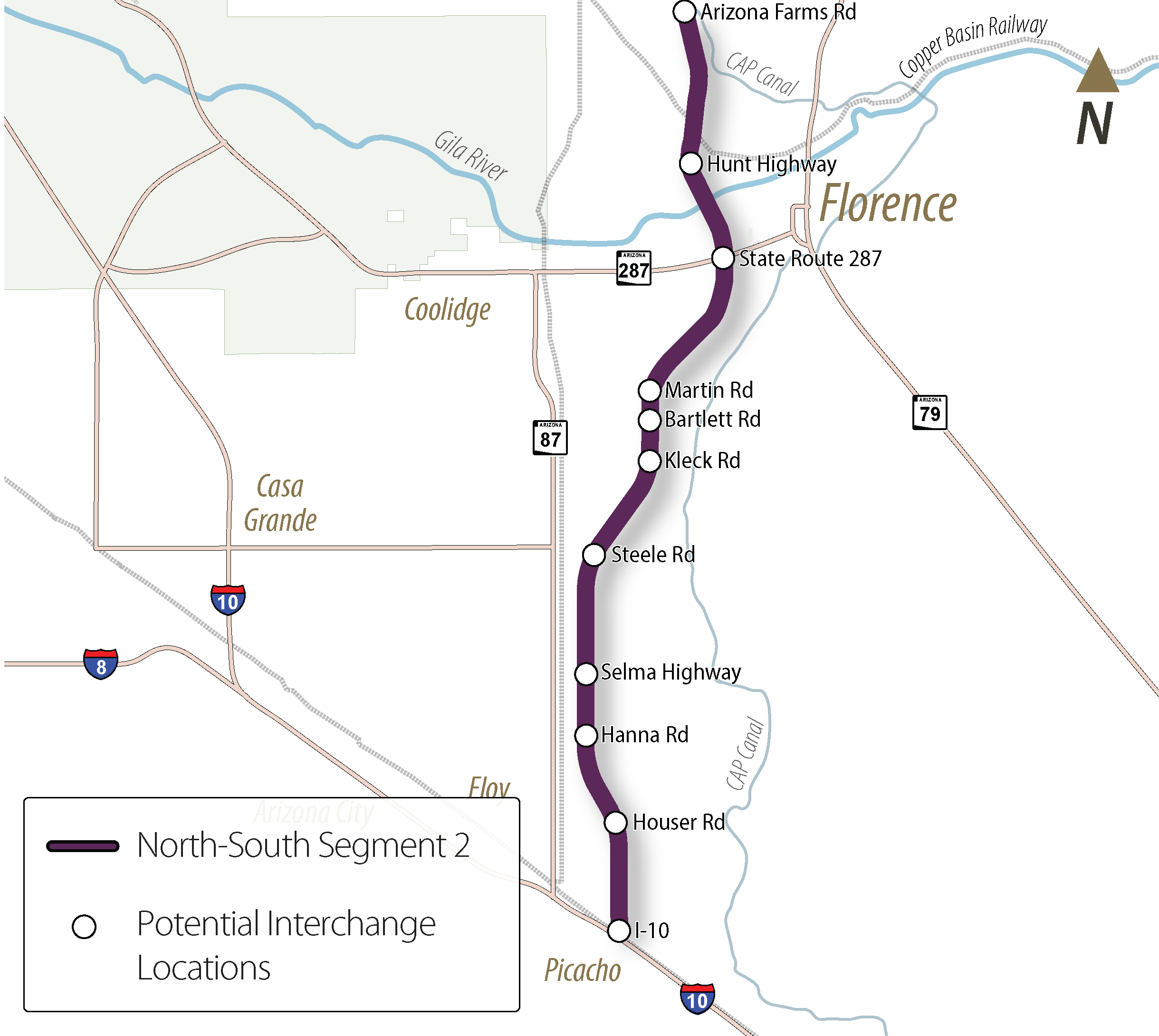
Tier 1 Potential Interchange Locations
In addition to identifying and evaluating a 400-foot North-South freeway alignment, the Tier 2 study will evaluate potential interchange locations.
The following potential interchange locations were identified in the North-South Corridor Study — Tier 1 EIS/DCR based on the future roadway network and will be further evaluated in the current study:
- Arizona Farms Road
- Hunt Highway
- State Route 287
- Martin Road
- Bartlett Road
- Kleck Road
- Steele Road
- Selma Highway
- Hanna Road
- Houser Road
- Interstate 10
Resources
Public Meeting Materials
Technical Resources
Tier 1 Final EIS/ROD
This Tier 1 Final Environmental Impact Statement and Record of Decision documents the potential effects associated with the proposed action corridor alternatives, which identify a new approximately 50-mile-long freeway between US 60 in Apache Junction and I-10 near Eloy and Picacho in Pinal County, Arizona.
Download PDF Interactive Document
Get Involved
Thank you for your interest in the North-South Corridor Segment 1 Study. The comment period for the current phase of the study was open from July 21 to September 8, 2025. As the study moves forward, ADOT will prepare a Draft Tier 2 EIS and an Initial DCR. The next opportunity for public input will be during the alternative development and evaluation comment period, which will be announced at a later date.